
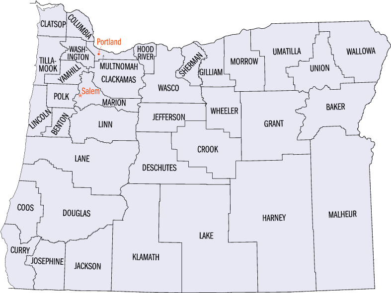
Here are Oregon’s counties –
And my Oregon cartogram –
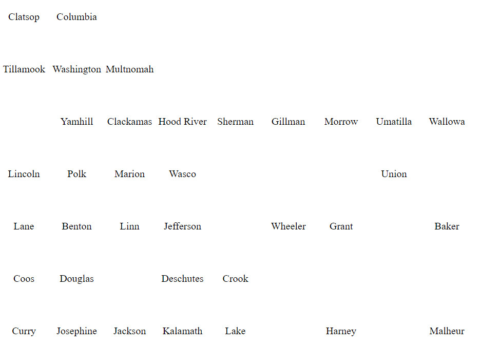
I’m really struggling with the lower left area where Lane, Benton, Deschutes, are/not lining up, but I hope the bank space I placed down there may give people a clue that something odd is going on.
I am also concerned about the blank areas on the lower right. There are some big counties in that part of the state. I opted to place data around the perimeter of the state to help in the overall Oregon state look, instead of nestling the data up with their neighbors. Again, I’m thinking the blank spaces will help caution people about the actual location of the data.
Here’s the simple table I used to create the above. There’s not much to it coding-wise but some consideration of placement. I want to make sure others know they are certainly free to use it. And I’d really like if anyone else has ideas on how to make a better one. Feel free to comment or drop me a note.
<!DOCTYPE html>
<html>
<head>
<style>

<!--
td{
  border: 1px solid black;
}
-->

table {
border-collapse: collapse
}

td {
    border: none;
}

td {
width:80px;
height:80px;
}

td {
text-align: center;
}

</style>
</head>
<body>
<table>
<!–– Creative Commons Attribution 4.0 International License, John Norris john-norris.net ––>
     <tr>
          <td>
             Clatsop
          </td>
          <td>
             Columbia
          </td>
          <td>
          </td>
          <td>
          </td>
          <td>
          </td>
          <td>
          </td>
          <td>
          </td>
          <td>
          </td>
          <td>
          </td>
     </tr>
     <tr>
          <td>
             Tillamook
          </td>
          <td>
             Washington
          </td>
          <td>
             Multnomah
          </td>
          <td>
          </td>
          <td>
          </td>
          <td>
          </td>
          <td>
          </td>
          <td>
          </td>
          <td>
          </td>
     </tr>
     <tr>
          <td>
          </td>
          <td>
             Yamhill
          </td>
          <td>
             Clackamas
          </td>
          <td>
             Hood River
          </td>
          <td>
             Sherman
          </td>
          <td>
             Gillman
          </td>
          <td>
             Morrow
          </td>
          <td>
             Umatilla
          </td>
          <td>
             Wallowa
          </td>
     </tr>
     <tr>
          <td>
             Lincoln
          </td>
          <td>
             Polk
          </td>
          <td>
             Marion
          </td>
          <td>
             Wasco
          </td>
          <td>
          </td>
          <td>
          </td>
          <td>
          </td>
          <td>
             Union
          </td>
          <td>
          </td>
     </tr>
     <tr>
          <td>
             Lane
          </td>
          <td>
             Benton
          </td>
          <td>
             Linn
          </td>
          <td>
             Jefferson
          </td>
          <td>
          </td>
          <td>
             Wheeler
          </td>
          <td>
             Grant
          </td>
          <td>
          </td>
          <td>
             Baker
          </td>
     </tr>
     <tr>
          <td>
             Coos
          </td>
          <td>
             Douglas
          </td>
          <td>
          </td>
          <td>
             Deschutes
          </td>
          <td>
             Crook
          </td>
          <td>
          </td>
          <td>
          </td>
          <td>
          </td>
          <td>
          </td>
     </tr>
     <tr>
          <td>
             Curry
          </td>
          <td>
             Josephine
          </td>
          <td>
             Jackson
          </td>
          <td>
             Kalamath
          </td>
          <td>
             Lake
          </td>
          <td>
          </td>
          <td>
            Harney
          </td>
          <td>
          </td>
          <td>
             Malheur
          </td>
     </tr>
</table>
</body>
</html>
I checked in with Oregon’s GIS dept, and they said they did not know of anyone doing anything similar at the State level.
Any ideas on how to make it better?


Pingback: Oregon Health Cartogram – Chronic cardio diseases by county | john-norris.net
Pingback: Oregon Health Cartogram – Depression by County | john-norris.net
Pingback: Monthly excess mortality across Oregon counties, a cartogram. | john-norris.net